
SparkFun RTK Torch – Beta Version – GPS-24672
The RTK Torch is the latest and greatest generation RTK product from SparkFun Electronics and is your one-stop shop for high precision geolocation and GIS needs. We compiled our wish list and got it all: tri-band reception, tilt compensation, and a built-in LoRa radio, all protected inside of a water proof housing.
That said, it’s not perfect. This SKU is the beta version of the RTK Torch and has the following issues potential users should be aware of:
- To sweeten the deal, this SKU will include 12 months of free corrections via PointPerfect.
- The firmware is very functional, but not feature complete. Be prepared to update firmware regularly and consider participating in giving feedback about how to make it even better!
- The LoRa radio is not yet active but may be in future firmware releases.
- The PPS, Bluetooth, and battery LEDs are a different color from the final version.
- The pocket in the carrying case is too tight, making removal of the device less than ideal.
- These units have four T9 security screws securing the antenna lid. These will be replaced with Phillips head screws in the final version.
For basic users, the RTK Torch is incredibly easy to get up and running; for advanced users, the RTK Torch is a flexible and powerful tool. With just the press of a button, the RTK Torch is the fastest way to take centimeter-grade measurements. 8mm Real Time Kinematic fixes are minutes away. By connecting your phone to the RTK Torch over Bluetooth, your phone or tablet can receive the NMEA output and work with most GIS software. This is exactly how $10,000 surveying devices have been operating for the past decade – we just made it faster, more precise, and a lot more economical.
The RTK Torch works with common GIS software for Android and iOS including SW Maps Android / iOS, Field Genius, SurvPC, Survey Master, Vespucci, QGIS, QField, and any GIS software that supports NMEA over Bluetooth.
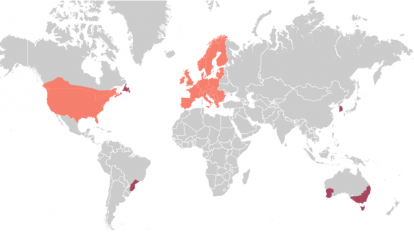
The RTK Torch includes a new feature we’re calling Zero-Touch RTK. Give the device the WiFi credentials for a hot spot or other WiFi network and it will begin getting corrections without any further setup. No NTRIP credentials required! These corrections are obtained over WiFi from u-blox PointPerfect available in the US, EU, and various parts of Australia, Canada, Brazil, and Korea (see the coverage map). This version of the RTK Torch includes a one month free subscription to PointPerfect. Additional annual subscriptions can be purchased if desired. If a subscription is not viable, corrections from a local base station or service can provided to the device over NTRIP (delivered via Bluetooth or WiFi).
We’ve listened to the feedback from our users and upgraded the housing to a fully IP67 rated, water proof to 1 meter for 30-minute enclosure (when the USB cover is closed). The RTK Torch comes in a hard sided carrying case with lots of room for a tablet, data collector, or other device.
Under the hood of the SparkFun RTK Torch is an ESP32, a UM980 L1/L2/L5 high precision GNSS receiver from Unicore, an IM-19 for tilt compensation, a 1W 915MHz LoRa radio, and a variety of peripheral hardware (LiPo fuel gauge, buzzer, etc). The addition of the L5 reception make this portable GNSS device ideal for densely canopied areas where normal L1/L2 reception may have problems. Additionally, housed under the dome of the RTK Torch is a light weight helical L1/L2/L5/Bluetooth/915MHz Band antenna. This antenna is a unique combination of elements designed to receive the GNSS signals (L1/L2/L5) alongside 2.4GHz for Bluetooth and 915MHz for long range radio communication. The built-in antenna has an ARP of 115.7mm from the base to the measuring point of the L1/L2/L5 antenna. The RTK Torch is programmed in Arduino and can be tailored by you to fit whatever your needs may be.
This device can be used in a variety of modes but these are six of the most common:
- GNSS Positioning (~400mm accuracy) – also known as ‘Rover’
- GNSS Positioning with RTK (8mm accuracy) – using a local base station
- GNSS Positioning with PPP-RTK (14 to 60mm accuracy) – using PointPerfect corrections
- GNSS Positioning with Tilt Compensation
- GNSS Base Station
- GNSS Base Station NTRIP Server
In Rover mode the RTK Torch will receive L1, L2, and L5 GNSS signals from the four constellations (GPS, GLONASS, Galileo, and BeiDou) and output the devices’ position with accuracies around 1000mm. The device will calculate the position based on the combination of GNSS and any correction signals. Similar to a standard grade GPS receiver, the RTK Torch will output industry standard NMEA sentences at 2Hz and broadcast them over any paired Bluetooth® device. The end user will need to parse the NMEA sentences using commonly available mobile apps, GIS products, or embedded devices (there are many open source libraries).
In Rover mode with RTK the RTK Torch will receive GNSS signals and combine them with RTCM correction data to achieve accuracy of approximately 8mm horizontal positional accuracy. The RTCM correction data is most easily obtained over a cellular connection to the Internet using a free app on your phone (see SW Maps or Lefebure NTRIP) and sent over Bluetooth® or WiFi to the RTK Torch. Correction data can come from free base stations or from a paid service.
In Rover mode with PPP-RTK the RTK Torch will receive GNSS signals and combine them with correction data provided over an IP connection (usually a cell phone hotspot). The corrections are State Space Representation (SSR) based and are also known as PPP-RTK. These corrections are obtained from ublox’s PointPerfect network. Time to RTK Fix can take up to 300 seconds and has 14 to 60mm horizontal positional accuracy.
In Rover mode with Tilt Compensation, once RTK Fix is achieved, tilt compensation can be enabled by tilting the unit back and forth on a surveyor’s pole. Once the IMU is activated, the outputted NMEA sentences will be modified to output the location of the tip of the pole (not the location of the receiver). This allows taking measurements near trees, structure corners, even underwater topographies with accuracies of +1cm when the tilt is less than 30 degrees, and +2cm when the tilt is less than 60 degrees.
In Base mode the device is mounted to a fixed position (like a tripod or roof) and will initiate a survey. After 60 to 120 seconds the survey will complete and the RTK Torch will begin transmitting RTCM correction data over the built in 2.4GHz radio. A base is often used in conjunction with a second RTK Torch unit (or RTK Facet, RTK Surveyor, Express, Express Plus, etc) set to ‘Rover’ to obtain the 8mm accuracy. Said differently, the Base sits still and sends correction data to the Rover so that the Rover can output a really accurate position. The relative accuracy of this mode is 8mm base-to-rover but has higher (up to a meter) of absolute inaccuracy. See how to setup a permanent base to decrease the absolute inaccuracy.
In Base mode with NTRIP the device will enter Base Station mode. If WiFi is available, its corrections will be broadcast to a NTRIP caster and made available to any rover that also has internet access and is within 10-20km.
The RTK Torch runs open source software meaning you can fully obtain, see, and even modify the functionality of the device. This allows for easier feature expansion, bug maintenance, and longer device longevity.
The SparkFun RTK Torch kit includes everything you need: the enclosed device, free correction subscription for 1 month, thread adapter, charger, data cables, and carrying case. It does NOT include a surveying pole. Any additional items will need to be purchased separately.
Important: While the SparkFun RTK Torch is fully water proof, we do not recommend it for permanent outdoor mounting. Please use the RTK mosaic-X5 or the RTK Reference Station that is located inside or protected from the elements. Or, for a DIY solution, the ESP32 attached to our ZED-F9P breakout is a great way to go. See our How to Build a DIY GNSS Reference Station tutorial for more information.